-
Notifications
You must be signed in to change notification settings - Fork 0
【Presentation】GBD论文写作规划和进度安排
[!TIP] Sketch Version
GBD: A Global-Scale Building Damage Dataset based on Diffusion Model
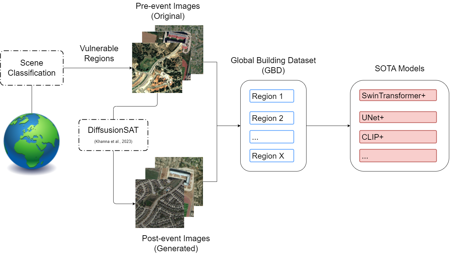
Object Detection of Damaged Buildings in disastrous event is important for aiding and reconstruction. //Current approaches for building damage assessment include CNN-based models and transformer-based models. However, these pre-trained model is still lack of general capability which fails to timeliness of detection in terms of disastrous events. //In this work, we propose a generative model ModelName to manufacture potential post-disaster images from vulnerable regions at global scale, be it GBD. //We find that after further training SOTA models on GBD, the performance of models show great improvements.

Khanna, S., Liu, P., Zhou, L., Meng, C., Rombach, R., Burke, M., Lobell, D., & Ermon, S. (2023, December 6). DiffusionSat: A Generative Foundation Model for Satellite Imagery. International Conference on Learning Representations (ICLR 2024). https://doi.org/10.48550/arXiv.2312.03606
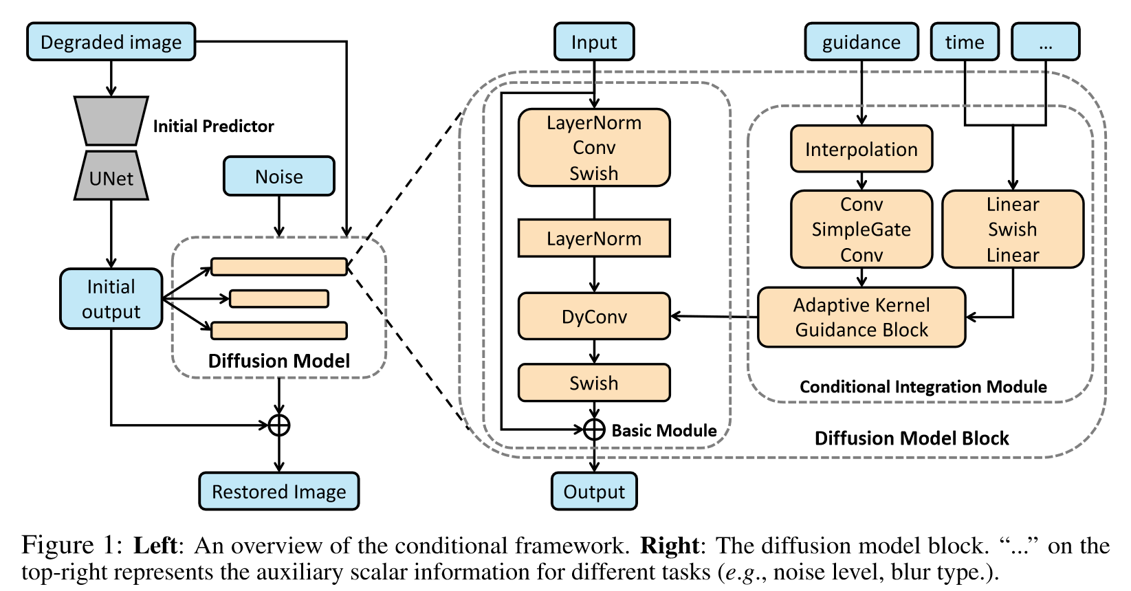
[!IMPORTANT] Backbone Network : UNet(Learning Knowledge) + Diffusion(Generation)
 Overview of Unified Conditional Framework for Diffusion-based Image Restoration (Zhang et al., 2023)
[!NOTE] Reference
Zhang, Y., Shi, X., Li, D., Wang, X., Wang, J., & Li, H. (2023). A Unified Conditional Framework for Diffusion-based Image Restoration. 37th Conference on Neural Information Processing Systems (NeurIPS 2023)
[!IMPORTANT] Main Contributions
-
We propose a generative model to synthesize labeled building damage dataset.
-
SOTA models undergo further training on our dataset shows considerable improvement in zero-shot for downstream tasks like segmentation, change detection and scene classification, especially in regions that has never been seen in the training dataset.
[!IMPORTANT] Key Points on Architecture
- Compared to natural images/synthetic images, RSIs have much more information regarding spatial relationship and so on.
- The extracted features of differences between pre-event RSIs and post-event RSIs is essential for image generation.
- RSIs is ideal to incorporate with contextual cues. In other words, vision-language pretraining (VLP) models would dramatically improve the performance.
Zhang, Y., Shi, X., Li, D., Wang, X., Wang, J., & Li, H. (2023). A Unified Conditional Framework for Diffusion-based Image Restoration. 37th Conference on Neural Information Processing Systems (NeurIPS 2023)
【0509】Introduction to FloodNet
Zhao, D., Lu, J., & Yuan, B. (2024). See, Perceive, and Answer: A Unified Benchmark for High-Resolution Postdisaster Evaluation in Remote Sensing Images. IEEE Transactions on Geoscience and Remote Sensing, 62, 1–14. https://doi.org/10.1109/TGRS.2024.3386934
【0516】Super-Resolution via a noval GAN & Compared to Diffusion Model to Generative Adversarial Model
Meng, F., Wu, S., Li, Y., Zhang, Z., Feng, T., Liu, R., & Du, Z. (2024). Single Remote Sensing Image Super-Resolution via a Generative Adversarial Network With Stratified Dense Sampling and Chain Training. IEEE Transactions on Geoscience and Remote Sensing, 62, 1–22. https://doi.org/10.1109/TGRS.2023.3344112
【0523】DiffusionSAT & 【交流总结】第九届青年地学论坛会议
Khanna, S., Liu, P., Zhou, L., Meng, C., Rombach, R., Burke, M., Lobell, D., & Ermon, S. (2023, December 6). DiffusionSat: A Generative Foundation Model for Satellite Imagery. International Conference on Learning Representations (ICLR 2024). https://doi.org/10.48550/arXiv.2312.03606
- Generative Models
- Zhang, Y., Shi, X., Li, D., Wang, X., Wang, J., & Li, H. (2023). A Unified Conditional Framework for Diffusion-based Image Restoration. 37th Conference on Neural Information Processing Systems (NeurIPS 2023)
- Meng, F., Wu, S., Li, Y., Zhang, Z., Feng, T., Liu, R., & Du, Z. (2024). Single Remote Sensing Image Super-Resolution via a Generative Adversarial Network With Stratified Dense Sampling and Chain Training. IEEE Transactions on Geoscience and Remote Sensing, 62, 1–22. https://doi.org/10.1109/TGRS.2023.3344112
- ...
- Semantic Segmentation for RSI
- Cui, L., Jing, X., Wang, Y., Huan, Y., Xu, Y., & Zhang, Q. (2023). Improved Swin Transformer-Based Semantic Segmentation of Postearthquake Dense Buildings in Urban Areas Using Remote Sensing Images. IEEE Journal of Selected Topics in Applied Earth Observations and Remote Sensing, 16, 369–385. https://doi.org/10.1109/JSTARS.2022.3225150
- Diakogiannis, F. I., Waldner, F., Caccetta, P., & Wu, C. (2020). ResUNet-a: A deep learning framework for semantic segmentation of remotely sensed data. ISPRS Journal of Photogrammetry and Remote Sensing, 162, 94–114. https://doi.org/10.1016/j.isprsjprs.2020.01.013
- Long, J., Shelhamer, E., & Darrell, T. (2015). Fully convolutional networks for semantic segmentation. Conference on Computer Vision and Pattern Recognition (CVPR), 3431–3440. https://doi.org/10.1109/CVPR.2015.7298965
- Yang, X., Li, S., Chen, Z., Chanussot, J., Jia, X., Zhang, B., Li, B., & Chen, P. (2021). An attention-fused network for semantic segmentation of very-high-resolution remote sensing imagery. ISPRS Journal of Photogrammetry and Remote Sensing, 177, 238–262. https://doi.org/10.1016/j.isprsjprs.2021.05.004
- Zhang, C., Jiang, W., Zhang, Y., Wang, W., Zhao, Q., & Wang, C. (2022). Transformer and CNN Hybrid Deep Neural Network for Semantic Segmentation of Very-High-Resolution Remote Sensing Imagery. IEEE Transactions on Geoscience and Remote Sensing, 60, 1–20. https://doi.org/10.1109/TGRS.2022.3144894
- Zheng, Z., Zhong, Y., Wang, J., & Ma, A. (2020). Foreground-Aware Relation Network for Geospatial Object Segmentation in High Spatial Resolution Remote Sensing Imagery. Computer Vision and Pattern Recognition (CVPR), 4095–4104. https://doi.org/10.1109/CVPR42600.2020.00415
- Others
- Li, Q., Mou, L., Sun, Y., Hua, Y., Shi, Y., & Zhu, X. X. (2024). A Review of Building Extraction From Remote Sensing Imagery: Geometrical Structures and Semantic Attributes. IEEE Transactions on Geoscience and Remote Sensing, 62, 1–15. https://doi.org/10.1109/TGRS.2024.3369723
- Zhao, D., Lu, J., & Yuan, B. (2024). See, Perceive, and Answer: A Unified Benchmark for High-Resolution Postdisaster Evaluation in Remote Sensing Images. IEEE Transactions on Geoscience and Remote Sensing, 62, 1–14. https://doi.org/10.1109/TGRS.2024.3386934
- ...
[!NOTE] Reference Zhao, D., Lu, J., & Yuan, B. (2024). See, Perceive, and Answer: A Unified Benchmark for High-Resolution Postdisaster Evaluation in Remote Sensing Images. IEEE Transactions on Geoscience and Remote Sensing, 62, 1–14. https://doi.org/10.1109/TGRS.2024.3386934
Gupta, R., Hosfelt, R., Sajeev, S., Patel, N., Goodman, B., Doshi, J., Heim, E., Choset, H., & Gaston, M. (2019). xBD: A Dataset for Assessing Building Damage from Satellite Imagery (arXiv:1911.09296). arXiv. https://doi.org/10.48550/arXiv.1911.09296


